21 apr. 2009

The Continuous Enclave: Strategies in Bypass Urbanism


"This thesis takes a formal approach to understanding the Israeli-Palestinian conflict by studying mechanisms of control within the West Bank. The occupation of the West Bank has had tremendous effects on the urban fabric of the region because it operates spatially. Through the conflict, new ways of imagining territory have been needed to multiply a single sovereign territory into many. It is only through the overlapping of two separate political geographies that they are able to inhabit the same landscape.


"The Oslo Accords have been integral to this process of division. By defining various control regimes, the Accords have created a fragmented landscape of isolated Palestinian enclaves and Israeli settlements. The intertwined nature of these fragments makes it impossible to divide the two states easily. By connecting the fragments through a series of under- and overpasses, the border between the two states has shifted vertically.


"One feature of the Oslo Accords is the bypass road which links Israeli settlements to Israel, bypassing Palestinian areas in the process. These are essential to the freedom of movement for the settlers within the Occupied Territories. Extrapolating on the bypass, this thesis explores the ramifications of a continuous infrastructural network linking the fragmented landscape of Palestinian enclaves. In the process, a continuous form of urbanization has been developed to allow for the growth and expansion of the Palestinian state. Ultimately, this thesis questions the potential absurdity of partition strategies within the West Bank and Gaza Strip by attempting to realize them."

DUISBURG NORD Landscape park, Germany


Location : Duisburg, Nordrhein-Westfalen, Germany
Client : Development Company of Nordrhein-Westfalen and the city of Duisburg
Construction Date : 1991-2000
Architects :
Latz and Partners
Awards : Winner of the 1990 international competition
Site Area : Park - over 200 hectares
Former industrial site - 20 hectares
Served population : 100 000 people living north of Duisburg


Landschaftspark is a public park located in Duisburg Nord, Germany. It was designed in 1991 by Latz + Partner (Peter Latz), with the intention that it work to heal and understand the industrial past, rather than trying to reject it. The park closely associates itself with the past use of the site: a coal and steel production plant (abandoned in 1985, leaving the area significantly polluted) and the agricultural land it had been prior to the mid 19th century.

In 1991 a co-operative-concurrent planning procedure with five international planning teams was held to design the park. Peter Latz’s design was significant, as it attempted to preserve as much of the existing site as possible (Diedrich, 69). Unlike his competitors, Latz recognized the value of the site’s current condition (Weilacher, 106). He allowed the polluted soils to remain in place and be remediated through phytoremediation, and sequestered soils with high toxicity in the existing bunkers. He also found new uses for many of the old structures, and turned the former sewage canal into a method of cleansing the site

design

The park is divided into different areas, whose borders were carefully developed by looking at existing conditions (such as how the site had been divided by existing roads and railways, what types of plants had begun to grow in each area, etc). This piecemeal pattern was then woven together by a series of walkways and waterways, which were placed according to the old railway and sewer systems. While each piece retains its character, it also creates a dialogue with the site surrounding it. Within the main complex, Latz emphasized specific programmatic elements: the concrete bunkers create a space for a series of intimate gardens, old gas tanks have become pools for scuba divers, concrete walls are used by rock climbers, and one of the most central places of the factory, the middle of the former steel mill, has been made into piazza. Each of these spaces uses elements to allow for a specific reading of time.
The site was designed with the idea that a grandfather, who might have worked at the plant, could walk with his grandchildren, explaining what he used to do and what the machinery had been used for. At Landschaftspark, memory was central to the design. Various authors have addressed the ways in which memory can inform the visitor of a site, a concept that became prevalent during
Postmodernism.

city of Curitiba, Brasil. A good example of urban planning


Curitiba’s Urban Planning - Lessons from Lerner

Jaime Lerner is the man behind Curitiba’s Master Plan. He started as an architect and urban-planner, and later brought his know-how to the city as the three-time Mayor of Curitiba (Capital of Paraná state) and twice as the Governor of the state.

Transportation

“Curitiba has a master planned transportation system, which includes lanes on major streets devoted to a bus rapid transit system. The buses are long, split into three sections (bi-articulated), and stop at designated elevated tubes, complete with disabled access. There is only one price no matter how far you travel and you pay at the bus stop. The system, used by 85% of Curitiba’s population, is the source of inspiration for the TransMilenio in Bogotá, Colombia, Metrovia in Guayaquil, Ecuador,as well as the Orange Line of Los Angeles, California, and for a future transportation system in Panama City, Panama.

Environmental Efforts

The city has also paid careful attention to preserving and caring for its green areas, boasting 54 m² of green space per inhabitant. At the Park Bariguí, the second largest urban park in Brazil, one can find sheep grazing on the periphery. Why, might you ask? Sheep are a lot less expensive than full-time workers and the grass it provides is enough to keep them fed and happy on the job. Other social projects are in place to encourage the growth of green living, such as a long-running recycling program and a waste-for-food exchange between the government and the poorest residents. All around Curitíba, one can take notice of the ways in which abandoned buildings and would-be parks were transformed into ‘creativity centers’ and even the city’s opera house, Ópera de Arame, situated in the Parque das Pedreiras (Pictured below).

Free Educational Centers

At the same time the city implemented its one-fare system, it also began a project called the “Faróis de Saber” (Lighthouses of Knowledge). These Lighthouses are free educational centers which include libraries, Internet access, and other cultural resources. Job training, social welfare and educational programs are coordinated, and often supply labor to improve the city’s amenities or services, as well as education and income. Due to these ‘Lighthouses’, Curitiba boasts one of the highest literacy rates in the country.”

I recently came across a very interesting
short 15-minute documentary in English which reinforces what I’ve said in the previous post. It’s simply brilliant.

16 apr. 2009

City Lounge by Carlos Martinez


City Lounge is an outdoor space in the center of St. Gallen, Switzerland, that has been designed by Carlos Martinez in collaboration with Pipilotti Rist, as a result of a design competition to create a public living room.
A red carpet flows all around the buildings, recreating places to relax, places to converse, places to park, fountains, even fake cars you can climb on.
It’s an amazing project that brings life to the city.

15 apr. 2009

Zoo de Vincennes. Paris


These are some plans for a new zoological park in Vincennes, France. The zoo's landscapes are designed by TN PLUS Landscape Architects, its buildings by Paris architects Beckmann N'Thepe. The project is noteworthy for, among other things, what could be called its simulated geology.
These artificial earthforms will contain simulated environments within which animals will live. The whole complex will encompass 15 hectares and six "biozones," and it will run partly on solar power.
The park's "biozones" include the savannah, the equatorial African rain forest, Patagonia, French Guiana, Madagascar, and Europe
So the zoo – like all zoos, of course – will be a simulation intended for animals. Zoos, in other words, are a particularly bizarre form of trans-species communication, attempted on the level of architecture and landscape design. They're like hieroglyphs that animals inhabit – spaces defined entirely by their ability to refer to something they are not.
And I have to say that the renderings of this place look pretty cool. But why do we only build zoos like this? Why not suburbs or college campuses? You mold landforms out of reinforced concrete, and you install artificial waterfalls and fake rivers, and you grow rare orchids under the cover of geodesic domes. And then your grandkids can grow up in a savannah-themed suburb outside Orlando. The next town over, kids run around through giant fern trees, chasing parrots. Perhaps themed biozones are the future of suburban design?

Riem Park - Munchen, Germania


Until 1992, Munich-Riem was where airplanes took off and landed.
Moving the airport to the Erdinger Moos made it possible to realise the municipal council’s courageous decision to build a suburb named after the new trade fair: Messestadt Riem. On the 560- hectare grounds of the airport, this meant setting up trade fair facilities, employment for 13,000 people and housing for 16,000, and of course a large landscape park intended to link the new city district to the surrounding municipalities.
An international ideas and realisation competition was held in 1995 for the “Landscape Park Riem” on the southern third of the former airport.
The very extensive and multi-level competition programme called for a timely park design that takes recreation, landscape composition and ecology into consideration. The first prize was awarded to the design by Latitude Nord of Paris.
The landscape architects Gilles Vexlard and Laurence Vacherot understood how to represent the woodlands of the southeast of Munich and the open fields of the northeast in the park in the form of broad expanses of meadows subdivided by forest masses, with the addition of tree clusters, strips of trees and individual trees. The diagonal structure of the plantings and pathways is oriented on the historical boundaries of the lots that left their imprint on the land before the airport was built. The park is open in all directions and joins up the new Messestadt Riem with the bordering municipalities.
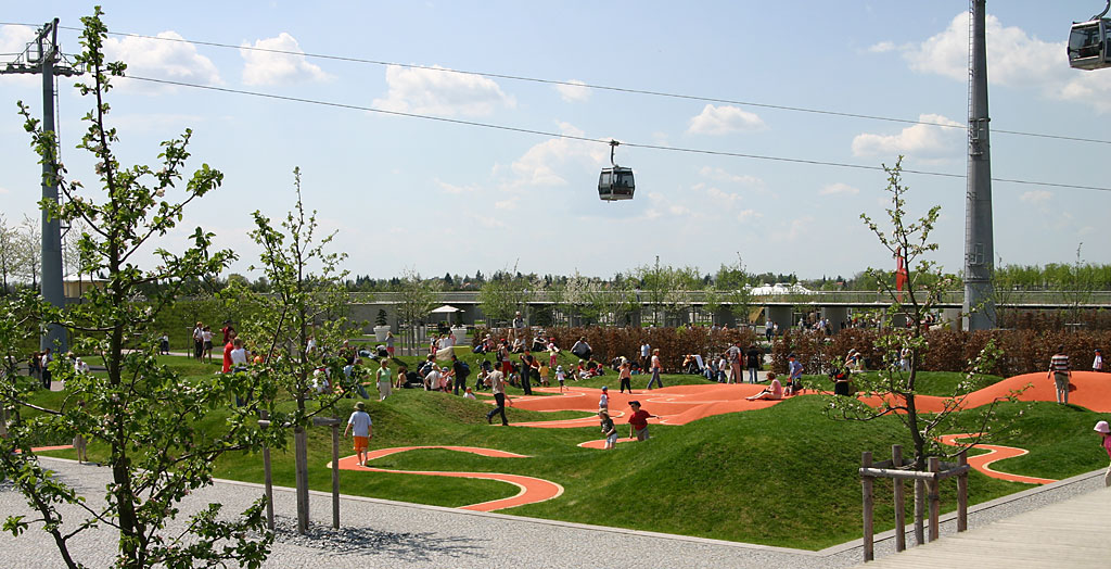
Running east west, a 180-metre-wide strip for various activities extends for 2.5 kilometres between the new Messestadt and the new park landscape. This contains recreational facilities for active uses, with areas for games and sports; in the east, the strip leads to a ten-hectare lake designed for swimming and to two geometrically shaped sledding and lookout hills composed mainly of rubble from the demolished airport. In the west are four large Sunken Gardens. Other beds of perennial plantings are
in the Parallel Gardens.
Most of the southern part of the park is designed to closely resemble the natural landscape, mostly consisting of lean grassland, meadows with a wealth of plant species and areas of woody perennials. Especially striking is the long extended meadow of perennials with an aspect predominantly of iris and mint on the south shore of the lake. The plants in the park correspond to the indigenous plant communities of the Munich gravel plain’s natural area.
Important aspects of the park design are the proportions and perspectives
with which it stages the breadth. The arrangement of the trees creates spaces and sequences of spaces that give the park depth. Over 20,000 trees were arranged according to a detailed planting plan; some of these blocks of trees were planted on raised beds of earth to provide the experience of different heights. The pathways are superimposed over the plantings as an independent layer. They form extended straight lines or axes and underscore the experience of breadth. On clear days you can see the Alps south of the park.
One of the important architectural elements in the park is the terrace wall that delimits the strip of activities. Inserted at regular intervals are 193 bronze plaques with aerial views of landscapes all around the world on the same latitude of 48°09’ as Munich. The landscape architect Gilles Vexlard comments: “The basic idea with the park is to create a place that
expresses the influence of the human intellect. A place that also brings to mind that a park is a human creation and comes about through a human decision.”
Riemer Park was inaugurated during the 2005 National Garden Festival in Munich and has been open since the spring of 2006 for unlimited access to Munich residents and their guests. Not all park visitors so far have made friends with the dimensions of the park and the axial pathways. But when the trees have been given time to grow and when the intended
spatial effects and compositions come about, people will appreciate that a generous design that can do without little designed bits and pieces was realised here.